Aerial image 119204
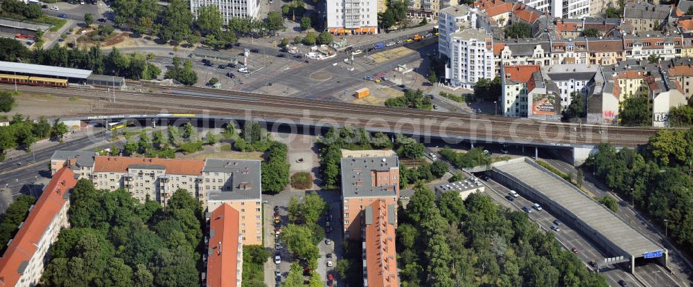
Blick auf den Innsbrucker Platz in Tempelhof-Schöneberg, Berlin. Erbaut 1910, bildet der Platz die Nahtstelle der Ortsteile Schöneberg und Friedenau. Am südlichen Rande des Platzes befindet sich die Ringbahnstation und U-Bahnstation Innsbrucker Platz. Auch die Stadtautobahn führt am Innsbrucker Platz vorbei, die Hauptfahrbahnen liegen im Tunnel komplett unter dem Platz. View at the Innsbrucker Platz in Tempelhof-Schöneberg, Berlin. Built in 1910, the place, the square is the interface of the districts of Schöneberg and Friedenau. At the southern edge of the square is the Ringbahn and subways station Innsbrucker Platz. The city highway passes the Innsbrucker Platz, the main roads are in the tunnel under the square completely.
BERLIN 27.07.2010
Aerial image ID: 119204
Image resolution: 4256 x 1768 pixels x 24 bit
compressed image file size: 2,61 MB
Image file size: 21,53 MB
Sources and credit: © euroluftbild.de/Robert Grahn
The recording is permitted due to the so-called freedom of panorama according to § 59 UrhG. The provision of Section 59 UrhG conforms to the directive based on Art. 5 Para. 3 Letter c of Directive 2001/29/EC of the European Parliament and of the Council of May 22, 2001 on the harmonization of certain aspects of copyright and related property rights in the information society ("InfoSoc-RL") to be interpreted. The directive-compliant interpretation shows that aerial photographs are also covered by § 59 Para. 1 UrhG and the use of tools does not lead out of the protective barrier. www.klebba.legal