Aerial Photo Database
Fulltext
  • Fulltext
  • Place

Search for place, image id, term(s)

Only search for place

Aerial photograph 119351
Blick auf die Gilberg-Insel im Biggesee, einem knapp 9 Quadratkilometer großen Stausee in Nordrhein-Westfalen. Die unbewohnte Insel entstand nach der Flutung des Biggesees und bildet mit der mit der benachbarten Uferregion ein Naturschutzgebiet. View of Gilberg Island in the lake Biggesee, an almost 9 square-kilometer storage lake in North Rhine-Westphalia. The uninhabited island was created by the flooding of the Biggesee and forms with the adjacent shore region a protected area.

ATTENDORN 10.10.2008
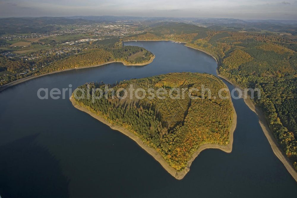
Attendorn from the bird's eye view: Blick auf die Gilberg-Insel im Biggesee, einem knapp 9 Quadratkilometer großen Stausee in Nordrhein-Westfalen. Die unbewohnte Insel entstand nach der Flutung des Biggesees und bildet mit der mit der benachbarten Uferregion ein Naturschutzgebiet. View of Gilberg Island in the lake Biggesee, an almost 9 square-kilometer storage lake in North Rhine-Westphalia. The uninhabited island was created by the flooding of the Biggesee and forms with the adjacent shore region a protected area.
Thematically related aerial photos
https://www.aerialphotosearch.com/info/aerial-photos/blick-gilberg-insel-biggesee-einem-knapp-quadratkilometer-grossen-stausee-nordrhein-westfalen-unbewohnte-insel-entstand-nach-flutung-biggesees-bildet-mit-benachbarten-uferregion-naturschutzgebiet-view-gilberg-island-lake-biggesee-almost-square-kilometer-storage-lake-north-rhine-westphalia-uninhabited-island-was-created-flooding-biggesee-forms-with-adjacent-shore-region-protected-area-119351.html https://www.aerialphotosearch.com/info/aerial-photos/blick-gilberg-insel-biggesee-einem-knapp-quadratkilometer-grossen-stausee-nordrhein-westfalen-unbewohnte-insel-entstand-nach-flutung-biggesees-bildet-mit-benachbarten-uferregion-naturschutzgebiet-view-gilberg-island-lake-biggesee-almost-square-kilometer-storage-lake-north-rhine-westphalia-uninhabited-island-was-created-flooding-biggesee-forms-with-adjacent-shore-region-protected-area-119351.html

Photo: Hans Blossey

Aerial image ID: 119351
Image resolution: 5616 x 3744 pixels x 24 bit
compressed image file size: 6,22 MB
Image file size: 60,16 MB
Sources and credit: © euroluftbild.de/Hans Blossey

The recording is permitted due to the so-called freedom of panorama according to § 59 UrhG. The provision of Section 59 UrhG conforms to the directive based on Art. 5 Para. 3 Letter c of Directive 2001/29/EC of the European Parliament and of the Council of May 22, 2001 on the harmonization of certain aspects of copyright and related property rights in the information society ("InfoSoc-RL") to be interpreted. The directive-compliant interpretation shows that aerial photographs are also covered by § 59 Para. 1 UrhG and the use of tools does not lead out of the protective barrier. www.klebba.legal

Keywords