Aerial image 120770
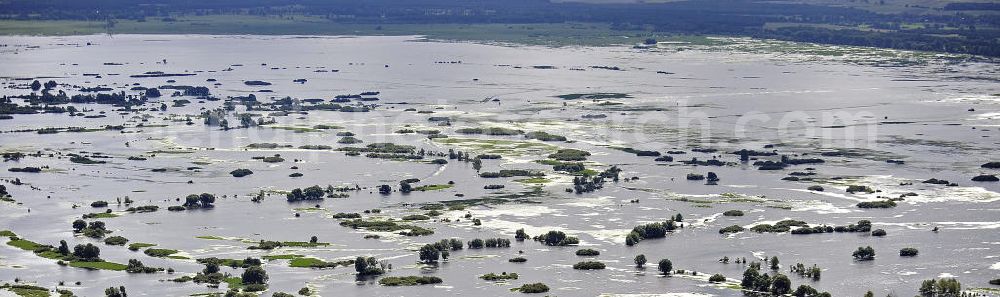
Blick auf das Überschwemmungsgebiet des Nationalparks Warthemündung. Der 2001 gegründete Nationalpark liegt an der Mündung der Warthe in die Oder und umfasst eine Fläche von 8.038 Hektar. Es dominieren Wiesen- und Weideland. View of the floodplain of the National Park Warta Mouth. Founded in 2001, this National Park is located at the mouth of the Warta River into the Oder River and covers an area of 8.038 hectares. It is dominated by meadows and pastures.
KOSTRZYN / KüSTRIN 17.08.2010
Aerial image ID: 120770
Image resolution: 4067 x 1212 pixels x 24 bit
compressed image file size: 1,73 MB
Image file size: 14,1 MB
Sources and credit: © euroluftbild.de/Robert Grahn
The recording is permitted due to the so-called freedom of panorama according to § 59 UrhG. The provision of Section 59 UrhG conforms to the directive based on Art. 5 Para. 3 Letter c of Directive 2001/29/EC of the European Parliament and of the Council of May 22, 2001 on the harmonization of certain aspects of copyright and related property rights in the information society ("InfoSoc-RL") to be interpreted. The directive-compliant interpretation shows that aerial photographs are also covered by § 59 Para. 1 UrhG and the use of tools does not lead out of the protective barrier. www.klebba.legal